
Post Offices in Bijapur(CGH), CHATTISGARH
Select the Post Office to see the address details:
PIN Code Finder
Pin Code or Postal Codes of India
A PIN Code (Postal Index Number) is a numerical code used by postal services to simplify the sorting and delivery of mail. Introduced by the Indian Postal Service on 15 August 1972, the PIN code system helps in efficient mail delivery across India.
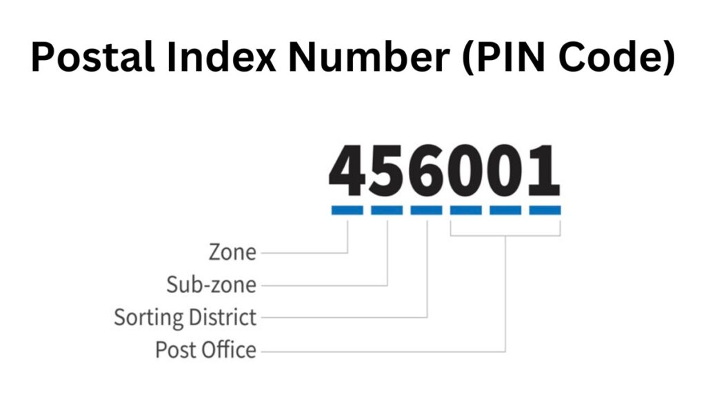
Structure of a PIN Code
A PIN Code consists of six digits, each representing a specific geographical region:
- First Digit – Represents the region (Zone)
- Second Digit – Represents the sub-region (Circle)
- Third Digit – Represents the sorting district
- Last Three Digits – Represent the specific post office
Postal Zones in India
There are nine postal zones in the country of which eight are regional and one is used for the Indian Army. The first digit of the PIN code designates the zone and is used across the 9 zones or regions that are spread across India:
| PIN Code 1st Digits | Zone or Region |
| 1 | Chandigarh, Himachal Pradesh, Jammu & Kashmir, Haryana, Punjab, Delhi |
| 2 | Uttar Pradesh, Uttarakhand |
| 3 | Dadra & Nagar Haveli, Daman & Diu, Rajasthan, Gujarat |
| 4 | Chhattisgarh, Madhya Pradesh, Maharashtra, Goa |
| 5 | Telangana, Andhra Pradesh, Karnataka |
| 6 | Puducherry, Lakshadweep, Tamil Nadu, Kerala |
| 7 | Andaman & Nicobar Islands, Sikkim, Assam, Meghalaya, Mizoram, Tripura, Manipur, Arunachal Pradesh, Nagaland, West Bengal, Odisha |
| 8 | Bihar, Jharkhand |
| 9 | Field Post Office (FPO), Army Post Office (APO) |
Postal Circles in India
India is divided into 23 Postal Circles. One state can have multiple postal circles and one postal circle can be sub-divided and shared amoung multiple states depending on the volume of mail handled in a region. Every state has one or more sorting districts or region which is headquartered at the main post office of the largest city in the region.
| Circle / Region Name | ISO Code | PIN Code Prefix |
|---|---|---|
| Delhi | DL | 11 |
| Haryana | HR | 12 – 13 |
| Punjab | PB | 14 – 15 |
| Chandigarh | CH | 16 |
| Himachal Pradesh | HP | 17 |
| Jammu & Kashmir | JK | 18 – 19 |
| Uttar Pradesh, Uttarakhand | UP, UK | 20 – 28 |
| Rajasthan | RT | 30 – 34 |
| Gujarat | GJ | 36 – 39 |
| Daman & Diu | DD | 396210 |
| Dadra & Nagar Haveli | DN | 396 |
| Maharashtra | MH | 40 – 44 |
| Goa | GA | 403 |
| Madhya Pradesh | MP | 45 – 48 |
| Chhattisgarh | CT | 49 |
| Telangana | TG | 50 |
| Andhra Pradesh | AP | 51 – 53 |
| Karnataka | KA | 56 – 59 |
| Tamil Nadu | TN | 60 – 64 |
| Puducherry | PY | 605 |
| Kerala | KL | 67 – 69 |
| Lakshadweep | LD | 682 |
| West Bengal | WB | 70 – 74 |
| Sikkim | SK | 737 |
| Andaman & Nicobar | AN | 744 |
| Orissa | OR | 75 – 77 |
| Assam | AS | 78 |
| Arunachal Pradesh | AR | 790 – 792 |
| Manipur | MN | 795 |
| Meghalaya | ML | 793 – 794 |
| Mizoram | MZ | 796 |
| Nagaland | NL | 797 – 798 |
| Tripura | TR | 799 |
| Bihar | BR | 80 – 85 |
| Jharkhand | JH | 80 – 83, 92 |
| Army Postal Service | APS | 90 – 99 |